| Watercharts |
|
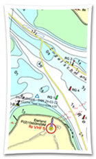
Stentec offers up-to-date and detailed nautical charts of the Netherlands, Belgium, Germany and the Danube. We also produce charts for Europes' coastal waters, the Caribbean islands and New-Zeeland. We collaborate with a.o. the Dutch Hydrographic Office, Rijkswaterstaat, Imray, Delius Klasing and NV-Verlag. |


 Perfect combination with WinGPS for planning routes on Dutch waters. Download it now and navigate the most detailed and up-to-date nautical chart of the Dutch...
 Upgrade now to the latest WinGPS and sail safely. Do you have an older version of WinGPS for Windows? We'd like to explain why it's recommended to use the...
 Are you heading to the Baltic Sea this year? With the DKW German Bight and DKW German Baltic Coast, you'll have a reliable and up-to-date base for your trip....