


|
Vaarkaart Friese Meren Available for free for iPad and iPhone. |
|
|

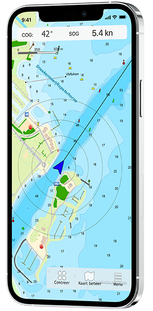 |
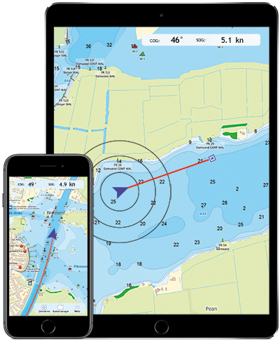
Vaarkaart Friese Meren for iOS This chart is perfect when you are planning a trip on the Frisian Lakes. Great while renting a boat, but also for skippers and crew of sailing boats, motorboats and sloops on the Frisian Lakes. Even while using a canoe or kayak or planning a fishing trip on the lakes this chart offers a clear image of your position of the beautiful Frisian landscape. The area this chart covers is from Stavoren, Makkum, Grou to Lemmer. Navigate on the Heegermeer, Fluessen, Morra, Oudegaster Brekken, Zwarte Brekken and Witte Brekken, Sneekermeer, Koevordermeer, Tjeukemeer, Langweerderwielen, Pikmeer/Wijde Ee and the many ditches, canals and pools. Depth image Processed within this chart is a unique, clear depth image received from the Friese Meren Project with beautiful colored depth levels and numbers along the water ways. Developed by Stentec in collaboration with Provincie Fryslân with the most recent depth measurements. This is a detailed chart with a scale of 1m/pixel, comparable with 1:3.000 on screen. The database accompanied with the chart has 3.393 waypoints and offers all kinds of useful water sports information. For example harbours, buoys, docks, water sport campsites and gas stations. |
Popular sailing chart for the Frisian Lakes
The DKW Vaarkaart Friese Meren has been available for Android and Windows since 2014 and has already been used by more than 60,000 water sports enthusiasts. More information about the Vaarkaart Friese Meren can be found at www.vaarkaartfriesemeren.nl
System requirements
Check via the link below if your device is suitable for this chart app. This app has the same system requirements as WinGPS Marine for iOS. In addition, you should take into account the size of the DKW Frisian Lakes charts. Check our online shop for the current size of these charts. |
Note: not every iPad has a built-in GPS receiver. If your device does not have an internal GPS receiver, you can use a bluetooth GPS receiver |

Harinxmastrjitte 29
8621 BJ HEEG
The Netherlands
T +31 (0) 515 443515


Copyright © Stentec Software. All rights reserved.
By using this website you acknowledge that you agree with our user agreement.